I. NOHOANGA TE MATANGI – POSITIONS OF THE WIND
A navigational system correlating a horizonal array of wind positions with other observable phenomena – e.g. swells, sunrise and sunset paths, celestial bodies, seasons, dynamic behavior of winds, solstices and equinoxes, voyaging routes, star paths, etc. – and built upon an awareness and perception of phenomena that are not taught in western navigation or seamanship.
Clarification and elaboration of the Nohoanga Te Matangi data was gained in several ways including those listed below:
A) Confirmation of my pre-NSF study research data in the 8 diagrams previously constructed showing:
1) 8 Primary Positions 2) 16 Secondary Positions 3) Full 32 named Positions 4) Sunrise and Sunset Positions 5) Seasons, Solstices, and Equinoxes 6) Strong and not strong Wind Positions 7) Celestial Bodies useful in Navigation Positions
B) Added new data to pre-NSF research diagram for one diagram (#8):
8) Routes (to known islands) – Positions with new added data
C) Expressed mostly new data in three diagrams (#s 9, 10, and 11):
9) “Man Pushing the Wind Back” – dynamic model of wind behavior through seasons 10) Actual Rise & Set detail of Celestial Bodies and Wind Positions, with new data 11) Star Courses for particular routes
During 2007 – 2008, I confirmed, primarily with Te Aliki Kaveia , the accuracy of the data represented in 11 diagrams I have constructed (and which Te Aliki Kaveia encouraged me to construct) that show data from the Nohoanga te Matangi navigation system (which is orally and experientially transmitted) during four sea-trials of 5 to 8 nautical miles offshore of Taumako, including two episodes of 2 hours each in full darkness. Below I have broken down the previously made drawings into their most basic types rather than combining the types as I had done prior to September, 2007. These are ordered in the order that they were taught to me by Te Aliki Kaveia.
Diagram 1: The 8 primary wind positions of the Nohoanga Te Matangi system, which are distributed with equal spacing around the 360 degree horizon (te maunga) with the viewer being located in the middle. These 8 positions are learned and thought of as 4 pairs of positions from opposites positions (180 degrees apart) around the horizon. Thus Te Alunga is paired with Te Haka Hiu, Te Tonga is paired with Te Tokelau, Te Ulu is paired with Te Palapu, and Te Laki is paired with Te Tokelau Tu. I plan to make electronic color-coding of the pairs to complete this diagram.
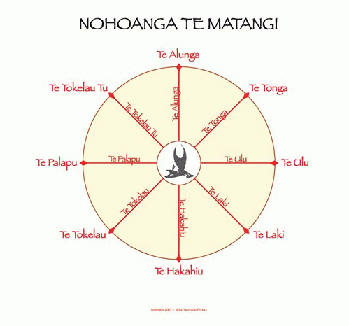
Diagram 1: 8 Primary Wind Positions
Diagram 2: The 16 secondary wind positions of the Nohoanga Te Matangi system. These are named as intermediate/combination names of the primary positions. The secondary names refer both to the exact positions as discrete points, and as sectors that comprise the entire arc between it’s end positions – such as the position point exactly in the middle between Te Alunga and Te Tonga being called Te Alunga Tonga; and entire arc or sector of Te Alunga to Te Tonga being called Te Alunga Tonga, including those ‘end points’.
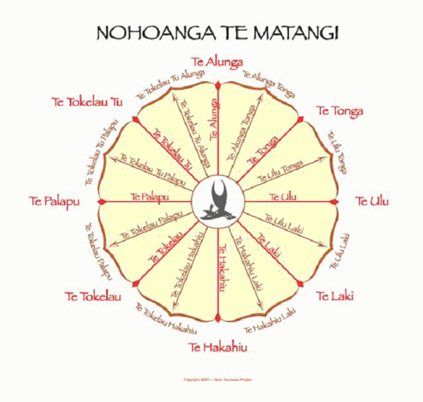
Diagram 2: 16 Secondary Wind Positions
Diagram 3: The 32 named wind positions of Nohoanga Te Matangi system -The naming system continues to be analogous to the European wind rose – with intermediary names of the 16 tertiary positions being combinations of closest neighboring positions.
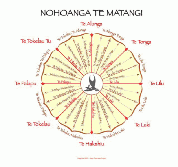
Diagram 3: All 32 Known Wind Positions
Diagram 4: Sunset/Sunrise Wind Positions – Looking at this diagram clockwise, the positions 1 – 4 Te Alunga through Te Tonga Ulu are positions at which the sun rises throughout the year in Taumako. The positions 1 – 4 entitled Te Tokelau Hakahiu Te Tokelau Hakahiu through Te Tokelau Palapu TeTokelau are the positions at which the sun sets.
Position pair 1) If the sun rises atTe Alunga it will set somewhere in the sector from Te Tokelau through Te Tokelau Palapu Te Tokelau.
Position pair 2) If the sun rises at Te AlungaTonga, if will set somewhere in the sector from positions Te Tokelau through Te Tokelau Hakahiu Te Tokelau.
Position pairs 3 and 4) If the sun rises at Te Tonga or Te Tonga Ulu, it will set somewhere in the sector from positions Te Tokelau Hakahiu through Te Tokelau Hakahiu Te Hakahiu.
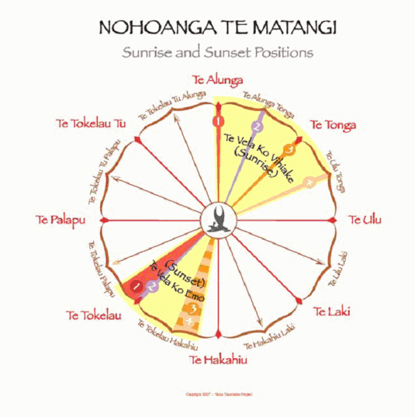
Diagram 4: Sunset & Sunrise Wind Positions
Diagram 5: Seasons and Calendrics – The positions Te Tokelau Tu through (clockwise) Te Ulu comprise the sector that comprises the positions of the trade wind season – Te Ngataei.
The positions from Te Laki through (clockwise) Te Palapu comprise the sector called Te Angeho – the season of cyclonic (westerly) winds.
The sectors from Te Ulu to Te Laki and from Te Palapu to Te Tokelau Tu are inter-seasonal sectors defined calendrically by the solstices and equinoxes at the beginning and end of each season. The cyclone season begins with the equinox and ends with the solstice.; and the trade wind season begins with the solstice and ends with the equinox.
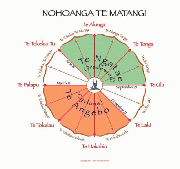
Diagram 5: Seasons and Calendrics
Diagram 6: The Strong and Not Strong Winds and Two Special Winds – The Strong trade wind season winds blow from Te Alunga through Te Tonga Ulu. The strongest trade wind winds blow from Te Alunga through Te Tonga. The strong cyclone season winds blow from Te Hakahiu Laki through Te Tokelau Palapu. The strongest cyclone winds blow from Te Hakahiu through Te Tokelau. The inter-seasonal periods of light winds and calms blow from Te Palapu through Te Tokelau Tu, and from Te Ulu through Te Laki.
Two of the “special winds” – winds that do not occur every year but are well known for their behavior – are call Te Vai Hapulu and Te Vaka Vei. Te Vai Hapulu starts blowing from Te Palapu and blows very hard – approximately 35 knots or more. During a period of about two weeks the position it blows from moves slowly counterclockwise around the horizon from Te Palapu through Te Tokelau Palapu through to Te Tokelau, and decreases in volume until it reaches Te Tokelau. Then, most times, another wind called Te Vaka Vei starts up strongly blowing from Te Tokelau at about 30 knots or more, and over a period of about two weeks it moves slowly around the horizon counterclockwise from Te Tokelau to Te Hakahiu, gradually decreasing in volume until it blows at about 20 knots when it finally reaches Te Hakahiu. When that happens, that is when it is safe for canoes to sail again. These are special winds common to the Reef Islands. There are other special winds common to Reefs and there are special winds common to other areas. Some of these special winds are known to blow throughout Temotu islands, though possibly not simultaneously at all the islands.
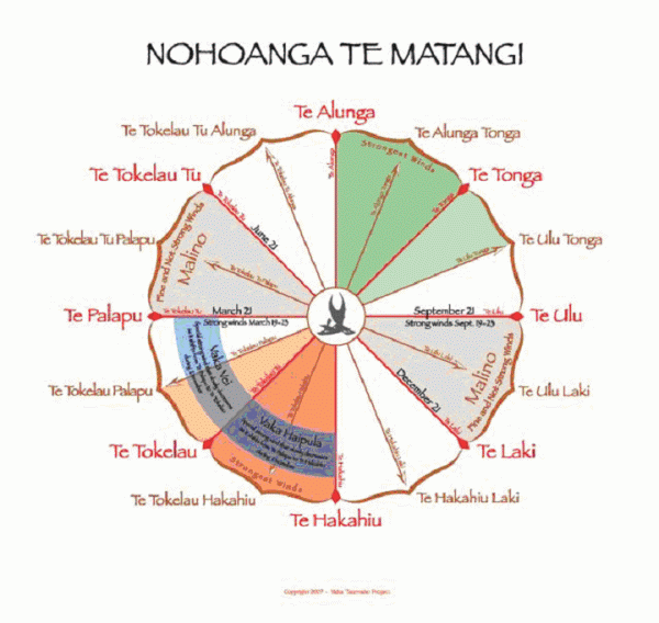
Diagram 6: Strong Winds, Not-Strong Winds, and 2 “No Special” Winds
Diagram 7: The “Man Pushing the Wind (Positions Back)” is the dynamic picture model of how the wind positions move clockwise from season to season and within the two main seasons.
Within any season the actual wind position that the wind blows from keeps shifting clockwise, moving through other positions around the horizon. Eventually the “man pushes” the wind back to the beginning position, or nearly to the original wind position, and the wind starts over asserting its tendancy to shift to positions further clockwise. The “man” has his arm out and is pushing the wind position back around counterclockwise. He attempts to return the wind to the original positions in the season, but as the season progresses he dies not succeed. When the man canno push it all the way back then he pushes it back to some nearly former position. In this way the man keeps losing positions over the course of the season the wind position gradually moves around the horizon clockwise until it sits on the very last position in the season. In the season of Te Ngatae, this would be Te Ulu. Then, when the man can no longer push the wind back into the season, the wind moves right through Te Hakahiu and on to Te Tokelau.
In these positions the wind is often light or calm. Then the wind takes up position in the beginning of the sector that comprises the next season. The man turns around and start pushing the wind back to the beginning position of that season. This diagram shows the man’s face simultaneously facing both ways while his arm is pushing counterclockwise back against the drift of the wind positions in a clockwise direction. But actually the man is pushing the wind position back in only one season or the other.
This simple model correlates with the behavior of wind as weather fronts work through an area during seasons of the year. It would be a useful conceptual tool for a non-instrument navigator in any open ocean on the earth.
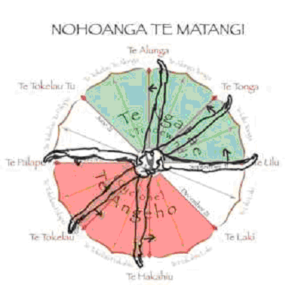
Diagram 7: “Man Pushing Back the Wind”
Diagram 8: Ten examples of Celestial Bodies that are Useful for Navigation when the Wind Comes from Certain Positions (and not useful when the wind is not coming from other positions) are diagrammed here.
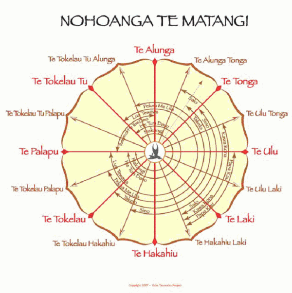
Diagram 8: Useful Celestial Bodies with Wind Positions
I am aware of 8 more celestial bodies that Taumako use for navigation. I will construct a similar diagram for them eventually.The concentric lines on the interior of this diagram each represents a star, planet, or constellation. The innermost ring is named Hakangi. It is a V shaped 7 star constellation named Hakangi. Hakangi is useful in navigation when the wind blows from every position except for the sector between Te Palapu and Te Tokelau Tu (moving clockwise). When Hakangi rises there is a strong wind for 5 days.
The second ring from the center is called Hetu Mdavo. It is the star group that English speakers call the Pleiades. Hetu Mdavo is useful in all winds positioned from Te Tokelau Tu through Te Palapu (moving clockwise). Like Hakangi, the only positions that Hetu Mdavo is not useful for navigation with are from Te Palalpu to Te Tokelau Tu. The third ring from the center is called “The Return of Hetu Mdavo”. This line shows the wind positions of Hetu Mdavo when it is not visible – when it is below the horizon.
Notice that it is the second half of the Return of Hetum Davo line that is useful for navigation – from Te Tokelau Tu to Te Alunga. Nohoanga Te Matangi navigators are using Hetu Mdavo for navigation when it is not visible above the horizon because when each of them first becomes visible over the horizon (annually), a 5 day Hetu Mdavo and Hakangi are called Hetu e Lua (the star couple) westerly wind begins to blow. These “winds of rising” occur during Te Ngatae season, when they may be seen to rise at around 5 AM. Hetu Mdavo is the first to rise -around 4 or 5 July. It is mentally pictured as the little eyes of birds, and when they rise from the sea they shake off their wings causing disturbed weather for 5 to 6 days. The next to rise is Lua Tawawa- the 4th celestial body from the center – which is useful for navigation in all the positions of Hetu e Lua, and which has no wind associated with it. Then Hakangi rises and brings 5 days of westerlies.
Hetu e Lua, Hakangi, and Sino also have Winds of Setting that occur in Te Angeho.
Paekea me Ula is actually a dark, crab-like shape paired with a dark, lobster-like, shape just north of east in the sky (seen from Taumako). Paekea and Ula help as sort of spacers before Takelo and Sino come rise to the south of east. Ula has no wind with it, but Paekea has a wind that comes from Tokelau when it rises. Takelo is the three people paddling in the canoe – which English speakers call the “belt of Orion.” When Takelo is up there is a extra dry reef during the day time. There is no wind associated with the rising of Takelo, but the wind becomes stronger toward the end of the day when the sea returns to the reef.
When Takelo rises above the horizon it is the start of 2 months of weather. The first month is bad weather with wind, rain, and rough seas. The second month the wind is not strong, there is no rain and no rough seas.
Sino is the brightest star in the sky – Sirius – and this is the center of the constellation Manu – which stretches widely across the sky. The other two stars are pictured as being the “wings” (Papakau Ndeni and Papakau) of Sino. When Papakau Ndeni rises there is a strong wind from Te Ulu for one day. When Papakau rises there is no strong wind. Papakau is farther from Sino than is Papakau Ndeni. The picture of why this is the case is that the short Papakau is a broken wing.
speakers call the “Southern Cross.” There is no wind associated with Kaua Kaua Kona are the stars that form the diamond in what English Kona.
LuooNa`i is the two “pointer stars” of the Southern Cross. When LuouNa`i rises there is one day of strong wind coming from variable directions.
When Sino rises there is 5 days of westerly winds.
Salo Tapio is 5 stars that form the picture of taro with two leaves, but no fruit underneath. There is no wind associated with Salo Tapio.
Salo Lavoi is 10 stars that form the picture of taro with two leaves (these are the same shape as Salo Tapio) along with 5 stars that are the fruit (corm) of the taro underneath. This Salo shows the way to Tikopia in Oct/Nove/Dec. There is no wind in it.
Kilika is the next constellation to rise and is not in this diagram. d. Diagram 9 is under construction. It will show the correlations between the Rise and Set and the wind positions for several stars:
Kaua Kona rises in Te Ulu Tonga and sets in Te Haka Hiu Laki Luona`I rises in Te Ulu Tonga, and sets in Te Haka Hiu Laki. These two are paired
Salo rises in Te Ulu Tonga and sets in Te Hakahiu Laki. Sino rises in Te Tonga and sets in Te Hakahiu Laki. Takelo rises in Te Tonga and sets in Te Tokelau Hakahiu. Lua Tawawa #1 rises in Te Tokelau Tu and sets in Te Tokelau Hakahiu
Lua Tawawa #2 rises in Te Palapu and sets in Te Tokelau Hetu. MDavo rises in Te Alunga and sets in Te Tokelau Palapu. The return of Hetu Mdavo rises in Te Alunga and sets in Te Tokelau
The short Papakau rises in Te Alunga tonga and sets in Te TokelauThe long Papakau Ndeni rises in Te Ulu and sets in Te Hakahiu Laki
The behaviors of these celestial bodies will be checked for consistency with astronomical tables for 10 degrees South.
By Dr. Mimi George for the National Science Foundation
